
Chenque. Vista hacia el noroeste. Detalle.
30 dic 1985. 2020 | 6:20am.

Chenque. Vista desde el Noroeste. 1984.
2020. 40 x 40 cm. Canson Baryta.

Chenque. Vista desde el sudoeste.
23 agosto 2021 | 8:14am.
2021. 40 x 40 cm. Canson Baryta.

Chenque. Vista aérea desde el Noroeste.
23 agosto 2021 | 8:10am.
2021. 40 x 40 cm. Canson Baryta.

Chenque. Vista desde la calle Sarmiento.
11 septiembre 2020 | 6:20am.
2020. 40 x 40 cm. Canson Baryta.

Chenque. Vista lateral hacia el noreste.
25 agosto 2021 | 2:22pm.
2021. 40 x 40 cm. Canson Baryta.
45°49’43.88″ S 67°29’37.89″ O
1 de enero 2021.

Chenque. Vista hacia el este.
25 agosto 2021 | 6:14pm.
2021. 40 x 40 cm. Canson Baryta.

Chenque. Vista hacia el sudeste.
23 agosto 2021 | 5:40 pm.
2021. 40 x 40 cm. Canson Baryta.

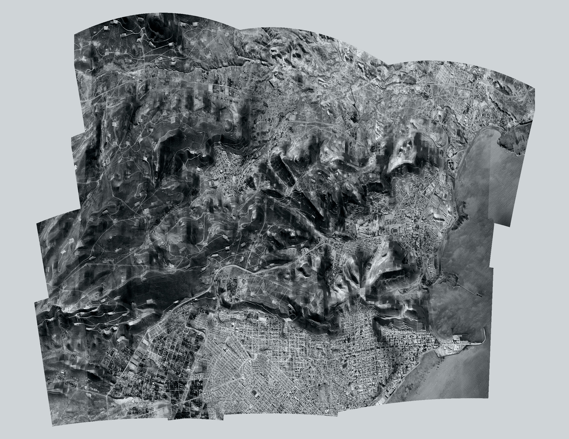
Chenque. Chubut. Mapa cenital.
2020. 150 x 110 cm. Canson Baryta.

Chenque. Vista hacia el noroeste.
30 dic 1985. 2020 | 6:20am.
2020. 40 x 40 cm. Canson Baryta.

Chenque. Vista hacia el Este.
23 agosto 2021 | 8:23 am.
2021. 40 x 40 cm. Canson Baryta.

Chenque. Vista hacia el nordeste.
24 agosto 2021 | 2:04 pm.
2021. 40 x 40 cm. Canson Baryta.

Chenque. Vista hacia el Sudoeste.
5 enero 1986 | 7:13pm.
2021. 40 x 40 cm. Canson Baryta.

Chenque. Vista hacia Comodoro Rivadavia.
24 agosto 2021 | 9:11am.
2021. 40 x 40 cm. Canson Baryta.

Chenque. Vista hacia pozos de petróleo.
24 agosto 2021 | 6:48pm.
2021. 40 x 40 cm. Canson Baryta.

45°49’43.88″ S 67°29’37.89″ O | Sep, 11, 2020.
2020. 110 x 60 cm. Canson Baryta.

45°49’43.88″ S 67°29’37.89″ O | Jun 12, 2020.
2020. 170 x 80 cm. Canson Baryta.
ES
Mi trabajo consiste en construir vistas, panorámicas y mapas con fotografías, imágenes satelitales y reconstrucciones 3D que busco en Google Earth (GE) y Google Street View (GSV).
En algunas ocasiones, mientras construyo mapas, modifico parámetros del programa (GE) para aterrizar de la mano de Pegman, el hombrecito naranja.
A nivel del suelo, la tierra despliega su relieve y los volúmenes de la arquitectura; el paisaje parece más real, aunque el algoritmo que ensambla nuestro mundo tridimensional todavía esté lejos de ser perfecto.
Aparecen las fallas, las faltas de información; se ven las cicatrices de la piel hecha de fotos que recubre las mallas del modelo 3D de la ciudad y sus alrededores.
Aprovecho para viajar en el tiempo: elijo la estación y la posición del sol más convenientes para fotografiar.
Practico el screenshotting (capturas de pantalla), un procedimiento que realizo íntegramente dentro de la computadora, relacionado con la apropiación y los videojuegos, y considerado en los límites de la fotografía (práctica asociada tradicionalmente con el uso de la cámara y la inscripción de la luz sobre una superficie fotosensible).
Es entonces cuando el mundo en línea por el que camino, sentada cómodamente frente a mi pantalla Retina de 27”, deja de ser una superficie plana y se transforma en algo semejante al escenario de un videojuego: un paisaje digital transitable, predefinido, simulado con polígonos y texturas, parecido en su aspecto al mundo real, pero mucho más bello, limpio y seguro.
Esta semejanza, cada vez más precisa y confusa, no deja de desorientarme. Me pregunto si estas imágenes que encuentro y me fascinan son índices de lo real o si me parecen reales porque se parecen a fotos.
Durante la primera cuarentena de la pandemia de COVID-19 fui invitada a participar en “Hacia un Socialismo Topográfico”, una plataforma en línea de trabajo colaborativo. Este trabajo fue realizado en colaboración con Archivo Tuna y Proyecto Visitantes, dos espacios autogestionados de la provincia del Chubut, Patagonia, Argentina, y tuvo como eje central el concepto de zona de sacrificio.
El cerro Chenque es emblema geográfico y simbólico distintivo de Comodoro Rivadavia: divide y atraviesa la ciudad, Capital Nacional del Petróleo. Su nombre se atribuye a la lengua de los pehuenches y significa cementerio o sepultura. El cerro está compuesto por materiales sedimentarios intercalados con bancos de ostreras fósiles y es parte de una meseta inestable que drena hacia el mar. A comienzos de los años ochenta, el área que ocupa fue categorizada como zona de “elevado riesgo geológico” por los deslizamientos naturales (movimientos de gran magnitud, rápidos y de difícil predicción temporal) que provocan aludes de tierra documentados desde las primeras décadas del siglo XX y que ocurren cada vez con más frecuencia. En 2012 se iniciaron las obras de aterrazamiento para liberar de peso los sectores críticos de riesgo.
Mientras la provincia del Chubut ampliaba su matriz extractivista de explotación de recursos energéticos, también profundizaba una de las mayores crisis políticas, sociales y económicas de su historia.
FICHA TÉCNICA
Marcela Magno. Chenque. 2020 / 2021. Inkjet sobre papel Canson Baryta 310 g. Tamaños variables: 40 x 40 cm, 60 x 40 cm, 110 x 80 cm.
EN
My work consists of building views, panoramas and maps with photographs, satellite images and 3D reconstructions that I search for in Google Earth (GE) and Google Street View (GSV).
Sometimes, while building maps, I modify parameters of the program (GE) to land hand in hand with Pegman, the little orange man.
At ground level, the earth unfolds its relief and the volumes of architecture; the landscape looks more real, even though the algorithm that assembles our three-dimensional world is still far from perfect.
Glitches appear, gaps in information; the scars show on the skin made of photographs that covers the meshes of the 3D model of the city and its surroundings.
I take the chance to travel in time: I choose the season and the position of the sun best suited to photographing.
I practice screenshotting, a procedure I carry out entirely inside the computer, related to appropriation and video games, and considered to lie at the limits of photography (a practice traditionally associated with the use of the camera and the inscription of light on a photosensitive surface).
It is then that the online world I walk through, sitting comfortably in front of my 27” Retina display, stops being a flat surface and becomes something like the setting of a video game: a navigable digital landscape, predefined, simulated with polygons and textures, similar in appearance to the real world, but far more beautiful, clean and safe.
This resemblance, ever more precise and confusing, keeps disorienting me. I wonder whether these images I find, and that fascinate me, are indices of the real, or whether they seem real to me because they look like photographs.
During the first lockdown of the COVID-19 pandemic, I was invited to take part in “Hacia un Socialismo Topográfico” (Towards a Topographic Socialism), an online platform for collaborative work. This work was made in collaboration with Archivo Tuna and Proyecto Visitantes, two self-managed spaces in the province of Chubut, Patagonia, Argentina, and its central axis was the concept of the sacrifice zone.
Cerro Chenque is the distinctive geographic and symbolic emblem of Comodoro Rivadavia: it divides and runs through the city, Argentina’s National Oil Capital. Its name is attributed to the language of the Pehuenche and means cemetery or burial place. The hill is made of sedimentary layers interbedded with fossil oyster banks, and it is part of an unstable plateau that drains toward the sea. In the early 1980s, the area it occupies was classified as a zone of “high geological risk” because of natural landslides (large, rapid movements whose timing is hard to predict) that trigger earthflows documented since the first decades of the twentieth century, and that occur with increasing frequency. In 2012, terracing works began to unload the critical risk sectors.
While the province of Chubut was expanding its extractivist model of energy-resource exploitation, it was also deepening one of the worst political, social and economic crises in its history.
TECHNICAL DETAILS
Marcela Magno. Chenque. 2020 / 2021. Inkjet print on Canson Baryta 310 g paper. Variable sizes: 40 x 40 cm, 60 x 40 cm, 110 x 80 cm.